From I-80/90 (Ohio Turnpike), take Exit 64 (I-75). Follow I-75 South to Exit 195 (OH-795 Perrysburg/Millbury) Turn left onto OH-795 (Avenue Rd.) and travel approximately 3.5 miles through Perrysburg. Fort Meigs is located on the west side of town and will be on the right-hand side. (OH-795/Avenue Rd. becomes Indiana Ave. becomes W. River Rd.)
From the East or West
From I-80/90 (Ohio Turnpike), take Exit 64 (I-75). Follow I-75 South to Exit 195 (OH-795 Perrysburg/Millbury) Turn left onto OH-795 (Avenue Rd.) and travel approximately 3.5 miles through Perrysburg. Fort Meigs is located on the west side of town and will be on the right-hand side. (OH-795/Avenue Rd. becomes Indiana Ave. becomes W. River Rd.)
From the North
From I-75, take Exit 195 (OH-795 Perrysburg/Millbury). Turn left onto OH-795 (Avenue Rd.) and travel approximately 3.5 miles through Perrysburg. Fort Meigs is located on the west side of town and will be on the right-hand side. (OH-795/Avenue Rd. becomes Indiana Ave. becomes W. River Rd.)
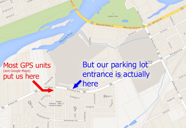
A Note for GPS Users
We’ve discovered most GPS units and online mapping services (like Google Maps) will get you to us but often they’ll incorrectly place the location of Fort Meigs’ entrance. Please take care with the last stage of your journey. See the image below for details
"About the time I broke out with mumps we Received marching orders to go to fort Meigs...Started for fort Meigs on a forced march without our tents or Camp Equippage...[sic] and it began to rain and rained on us two days in succession and almost without intermission and...I thought I should Die with misery."
~ William B.Northcutt, Volunteer Ball's Squadron, U.S. Light Dragoons